Understanding the historical significance and symbolic representations within the Babylonian Map of the World, the first known world map, gives us an unparalleled insight into the lives of the ancients.
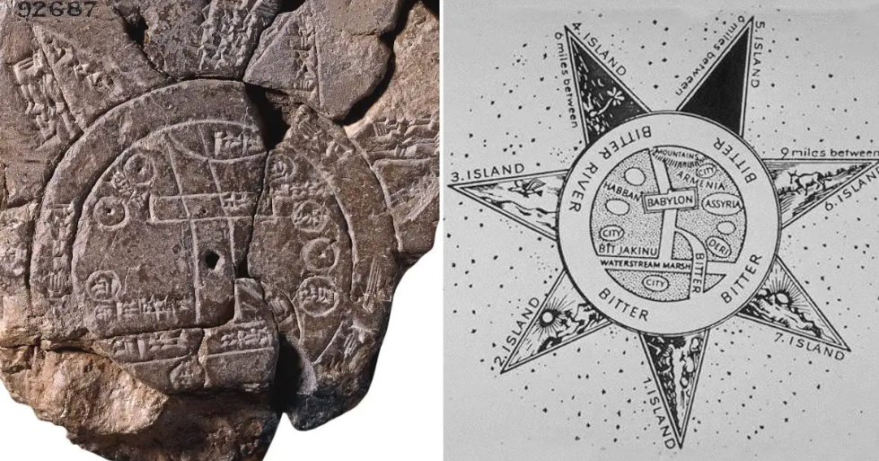
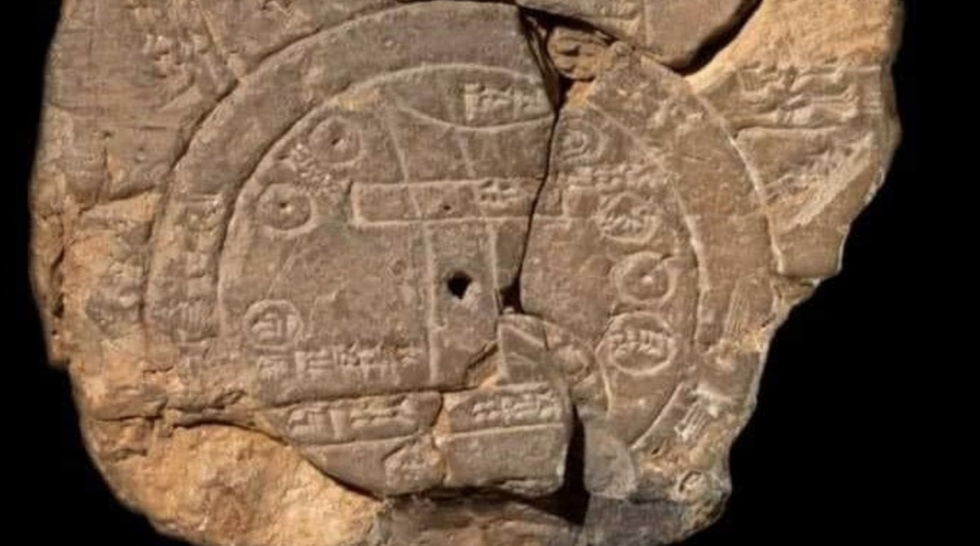
The oldest surviving world map is the Babylonian Map of the World, also known as the ‘Imago Mundi’. It is a clay tablet dated to 700-500 BCE that depicts the world as a circular disc with Babylon at the center. It was discovered by Hormuzd Rassam, a British archaeologist, in 1881 at Sippar, a city near Babylon in modern-day Iraq, and is presently kept at the British Museum in London.
Written in the Akkadian language, the Babylonian Map of the World is a fascinating artifact that provides insights into the ancient Babylonians’ understanding of the world. It is important to note that the map is not a perfect representation of the world, but it does show that the Babylonians had a basic understanding of geography. (Read more about its features below the map.)
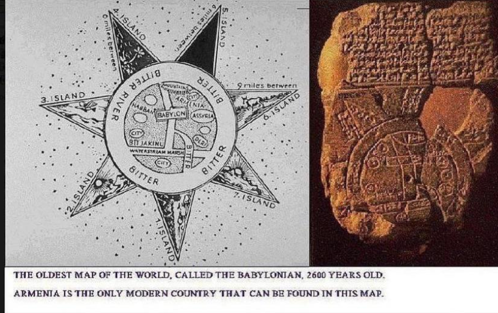
The map is circular and divided into two concentric circles. The inner circle represents the known world, centered on Babylon, which is shown as a rectangle near the top. This reflects the Babylonians’ belief that Babylon was the center of the world.
The Euphrates River flows through the center of the map, from north to south through Babylon. The Euphrates, a major river in Mesopotamia, played an important role in Babylonian culture and agriculture. The area right to the Euphrates is marked “marsh” and the left end is marked “outflow”, thus the marshes at the head of the Gulf and either the Shatt al-Arab or where the river meets the sea, or the cosmic “Bitter River” (see below).
Small circles are employed to signify cities or districts, two of which are labeled as “Assyria” and “Der.” Three additional geographical regions are delineated: Bit-Yakin, representing the territory of an Aramaean tribal group situated near the southern Euphrates, is positioned above its “outflow.” Habban, the homeland of a Kassite tribal group near Kermanshah in western Iran, is inaccurately situated to the west of Babylon. Urartu, an independent kingdom encompassing the modern borders of Iran, Turkey, and Russia, is relatively accurately placed to the north of Assyria.
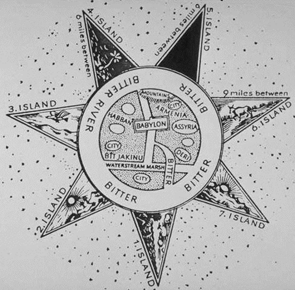
An interpretation of the main features of the Babylonian Map of the World. Image: Henry Davis via Johnny El-Rady
The outer circle represents a circular waterway, called the “bitter river” or the salt sea (Oceanus), which surrounds the land. This is a representation of the sea that the Babylonians believed surrounded the world.
Beyond the water, there are eight triangular outlying regions (nagu), each labeled as a “region” or an “island”. The text also gives the distances between these regions and Babylon. The nagus are thought to represent different parts of the world that were known to the Babylonians and are described in a cuneiform text above the map, which tells of the inhabitants, mythical creatures and legendary heroes that live either there, or the “Bitter River,” or maybe the underworld or underworld waters (two or three lines may be missing at the beginning:
“… ruined cities … … whom Marduk watches … … the ruined gods who … in the midst of the sea … serpent, great dragon, between Anzu, scorpion-man … mountain-goat, gazelle, zebu, leopard, bison … lion, wolf, stag and hyaena … the animal which Marduk created upon the rolling sea … Ut-Napis”
Furthermore, adjacent to the northeastern “area” is the inscription “Where Shamash is not seen.” This inscription mirrors the Babylonian belief that the sun rises in the east, traverses the skies, sets in the west, and subsequently returns to the east through the underworld or underworld waters, completely avoiding the northern (or southern) regions of the world or underworld.
A final paragraph summarises, “In all eight “regions” of the four shores (kibrati) of the ea[rth …], their interior no-one knows”.
The map is not meant to be a realistic or accurate representation of geography. Rather, it reflects the Babylonian worldview and cosmology, which was influenced by their religious beliefs and cultural traditions. The map shows how the Babylonians saw themselves as the center of the world, and how they imagined the unknown and exotic lands beyond their borders. The map also illustrates their concept of the universe as a flat disk surrounded by water, which was a common idea in many ancient cultures.
The Babylonian Map of the World is a unique and valuable artifact that gives us a glimpse into the ancient mind and helps us to understand the development of geography and cartography. It is also a testimony to the human curiosity and creativity that have driven us to explore and understand our world throughout history.
A sociologist and English major by degree, I’ve worked in the area of civil society & human rights and have been blogging in the fields of travel, nature & science for over 20 years.